Showing posts with label medieval maps. Show all posts

Tuesday, May 26, 2015

Writing Across Time and Space: My Paper about Elaine of Astolat at Kalamazoo 2015

*Before you read my Kalamazoo post, check out Kate's excellent Kalamazoo 2015 Round-up.*

I am just now recovering from the joyful exhaustion that characterizes the International Congress on Medieval Studies. Each year brings a more hectic schedule of events and reunions to the congress, with more people to see and more people I don't see enough. It always reminds me how lucky I am to be a part of such a wonderful and inclusive academic community. This congress was especially delightful and especially tiring. It's been a busy year for me so far. For those who don't yet know, I have some exciting news -- I've accepted a tenure-track position at Lyndon State College in Vermont, and I am focusing on finishing my dissertation and preparing to move. Perhaps, then, it makes sense that my Kalamazoo paper dealt with anxieties about writing and traveling. I presented on Elaine of Astolat, a woman who goes to great lengths to ensure that her words travel where/how she wants them to even after her death. I presented on a panel called "Sacred and Secular Road Trips in Middle English Romance," presided over by Eve Salisbury and organized by David Eugene Clark, Gina Marie Hurley, and Justin Lynn Barker. My panel was fantastic, featuring my co-blogger Leila (Kate) Norako, who presented on Virtual Pilgrimage, Elizabeth A. Williamsen, who presented on Sir Isumbras, and Amber Dove-Clark, who presented on Guy of Warwick.

My paper was called "Ascolat to Camelot, Guildford to Winchester: Narrative Travel in Malory’s Morte d'Arthur," and I've only just begin thinking on the topic. The q and a really gave me a lot of ideas, so the paper I give you here only represents my initial sketches on the geotemporalty in Elaine's story. Any ideas, questions, or critiques would be very welcome.

 *     *     *     *     *     *     *     *     *     *     *     *     *

Arthur Rackham image (1917)
courtesy of the Camelot Project
Elaine of Astolat may be dead, but she seems to be everywhere. Even as I speak, she is wending her watery way across the walls of museums, poster stores, and college dorm rooms worldwide. Her mythic status both fixes and unfixes her in time, allowing her to be always setting out for Camelot, always floating there, always arriving. She lives in the romance world and moves in romance time. Yet Malory's version of her tale connects her romance rivertrip from Ascolat to Camelot with real places, as Malory clarifies that Ascolat corresponds to contemporary Guildford and Camelot to Winchester. Elaine’s journey is a moment of geographical specificity in a text that often unfolds in a geotemporal haze. Her journey, despite its more fantastical elements, is granted a sense of real possibility, since the trip from Guildford to Winchester can be traced on a map. Guildford and Ascolat share the same ground, bringing the romance world and the historical world into startling proximity. Ever since Geoffrey of Monmouth, and perhaps before, Arthurian narrative has been sitting on the line between history and literature. How many of us have received questions from well-meaning friends and family members about whether or not Arthur was real? But the dynamic tension between history and romance takes new significance in Malory's version of Elaine's story, since her journey collapses clear boundaries between image and word, passive and active, here and gone.

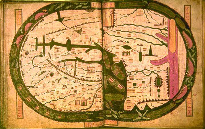
I connect this overlapping with medieval world maps, in which historical timelines are arranged geographically, the meaning of each piece of text rooted in spatial relation to other pieces of text. (Here's where Lot's Wife looked back, here's where Alexander the Great camped, etc. [You can find more of my thoughts on medieval maps here and here.]) The visual and narrative are mutually constitutive on these mappae mundi. In Malory, space and time collapse in ways similar to medieval maps, as Elaine’s body and letter are inextricable as she moves through a romance landscape that looks very much like a real one (or, perhaps, a real landscape that looks like romance). Multiple geographies and temporalities overlap as she becomes both visual spectacle and narrative conduit. She chooses to travel by river, a linear, teleological mode of transportation in which currents lead to her destination. She moves into a center of power, and yet asserts her own version of events so strongly that they are literally set in stone on her tomb. I contend that the simultaneity of multiple geographic and temporal modes in Elaine’s story call attention to the complicated and contradictory way in which her most powerful moment is also the end of her life, her most visible moment is also the pinnacle of her narrative authority. The fact that Elaine is most active and authoritative when she is dead and unable to move or speak works well with the convergence of historical and mythic time, since she is static and in motion, an image and a narrative. She embodies her letter, and her body and her story find their resting place in Camelot.

Though Elaine’s story is linear in that she floats from one location to another, Malory’s telling is also cyclical. (Again, like the world maps, which presented a linear narrative in a spatial way.) In essence, we get her story three times (at least) and in different ways. As soon as we meet her, Malory tells us that “she keste such a love unto sir Launcelot that she cowde never withdraw hir loove, wherefore she dyed,” giving us the tragic end to her story before it even begins (623). This particular Elaine exists inside the larger myth of the fair maiden of Astolat. There is thus a cyclical quality to this narrative defined by clear teleology. The tale, which itself has been retold, is retold in the text. The first version is simply part of her introduction, but important because it renders her introduction narrative rather than visual. We learn who she is and what she does (and notice how active these verbs are — she cast her love, she died), but not what she looks like. And, for the first time in her tradition, we get a name for her character, which allows her a subject position to go with all those active verbs. 

As we continue with the largest portion of the narrative, Elaine consistently communicates her own thoughts and wishes. She tells Launcelot (and Gawain, and everyone else, for that matter) directly of her love. She asks Launcelot to wear her favor, and later asks him to be her husband ... or at least her lover. She seeks him in a quest when she takes over Gawain's search, and then she directly interacts with his body as she heals it. Even as she performs the more traditionally feminine role of healer, she is only able to do so because she has taken on a knight's quest given by King Arthur himself. Launcelot's body is the object of both her quest and of her healing. Though her most famous (and most illustrated) voyage is her post-mortem one, she also seeks Launcelot on land (while alive) and succeeds in reaching him where Gawain fails.

Launcelot tries to give her options other than death, but she'll have none of it. He, not seeing the insult in his offer, attempts to provide her with a dowry to marry another, but she responds matter-of-factly: "Alas! Than', seyde she, 'I must dye for youre love'" (638). Her assertion troubles the world of the romance, since she is not imperiled in a way that allows for masculine rescue. As Dorsey Armstrong explains, "the Pentecostal Oath constructs male and female in terms of a binary which opposes active, aggressive masculinity to passive, helpless femininity" (45). Knights gain honor by saving damsels in distress. Yet neither Launcelot nor her brothers nor her father nor anyone else can save her once she asserts her coming demise. Molly Martin has pointed out that Perceval's sister, another lady in a boat, chooses to die in such a way that her brother cannot rescue her, and Elaine’s death is similarly outside of the chivalric system.

Instead, her death forms a new narrative all her own. Walsh notes that "Malory does not let Elaine die offstage, as she does in both the sources" (144). And it is in fact her death (and the related fact that we see her voyage from her perspective and thus vicariously journey with her to Camelot rather than just seeing her arrive) in Malory's version that creates such a strong sense of her character. As Martin points out, "Malory carefully reworks the material surrounding her death to show a particularly active Fayre maydyn creating an image of her own dead body" (154). Knowing that she'll die, she first requests to dictate a letter, and then describes the way in which her father and brother should arrange her body.  All of these requests are meant to prepare a narrative for the court, and all are meant to give her authorial control. The fact that she mentions the letter first means that all arrangements are in terms of that letter. Gawain may send a deathbed missive to Launcelot, but Elaine sends her deathbed. Her deathbed is in fact part of the missive. She requests, "'And whyle my body is hote lat thys letter be put in my ryght honde, and my honde bounde faste to the letter untyll that I be colde" (640). The letter thus provides the link between living and dead maiden. The willful clasp of warm hand will be  followed by the inert touch of cold fingers, but the letter will witness the moment of transition and remain. The further details she requests, to be put on a bed with rich clothes, to be taken to the Thames, and to have her barge covered in black samite, all function as extensions of this request for a written message (640). All these details are meant to be read and understood by the court in conjunction with the letter and to properly convey her version of herself and her story. She'll make a spectacular entrance, but also an epistolary one.

There are a number of ways that she maintains control over her letter. She asks that a mute oarsman row her barge, assuring that someone will be present to ensure the barge goes where she wants but that no one can provide an alternate version of her story. She travels by river, which, unlike an ocean voyage, has a specific direction. If we see the linear movement of the river as historical time, then Elaine's movement in history is brief and tragic. Martin B. Shichtman points out that Elaine “has no real story beyond that which can be summed up in two sentences. Her entrance into the realm of historical time is brief, incomplete, and fatal” (261). And this is certainly true. Yet it's also true that historical time here is not wholly separate from a-historical romance time. Joseph D. Parry discusses the way in which Malory locates Elaine's story in both Guildford, specifically locatable to a 15th century reader, and also Astolat, "a place firmly inscribed in the Arthurian landscape of surprise adventures" (159). He notes that the text "locates the river down which the Fair Maid's funerary procession travels, in two settings. One can locate the river – the Thames . . . in Malory's fifteenth-century world. But Elaine's final river trip is also a journey elevated to mythical status." Her journey thus complicates both spatiality and temporality. Meg Rowland calls Malory's manner of pairing mythical and 15th century locations "pluralistic geography," in conjunction with the coexistence of chronicle and romance time. Elaine's journey functions in such geographically and temporally complex ways. The movement of a river is narrative in itself, and combines the static quality of Elaine's dead body with the narrative quality of her story. Word and image, text and body, fuse as she makes her first and last trip to Camelot. 

As she floats to Camelot, everyone's talking about her, and she is ultimately able to squash all the rumors and give the last word on the subject. At fist, Arthur only notices the spectacle -- the corpse's great beauty and riches -- without understanding its full import. He does observe that "she lay as she had smyled" (640). Sue Ellen Holbrook points out that "the smile . . . is the sign of a soul at rest," and I think this sign is legible to the knights of the court (177). It is the queen who notices the letter and points it out to Arthur and the knights, thus recognizing the body's full narrative potential. The letter then gets a public audience, her version of the story read directly to all. Alan Lupack explains that "her arrival is . . . an elaborately staged performance. … The public display is important because it provides the setting for Elaine's letter" (260). I would even argue that the performance, the spectacle of it all, is part of the letter. Her letter is inextricable from her cold hand, from her beautiful face, from her smile, from her lovely garments, from the strange mode by which she enters the court.

The letter is Malory's third iteration of the Fair Maiden's tale; as a deathbed epistle, Elaine's version of events holds some authority. Malory expands upon this authority by giving us the letter in its entirety:
'Moste noble knyght, my lorde sir Launcelot, now hath dethe made us two at debate for youre love. And I was youre lover, that men called the Fayre Maydyn of Astolate. Therefore unto all ladyes I make my mone, yet for my soule ye pray and bury me at the leste, and offir ye my masse-peny: thys ys my laste requeste. And a clene maydyn I dyed, I take God to wytnesse. And pray for my soule, sir Launcelot, as thou arte pereless.' (641) 
As many critics have noted, this version of her letter differs from those that place blame on Launcelot. Malory's version focuses not on vengeance, but rather on asserting Elaine’s own character and providing her personal narrative. As Georgiana Donavin explains, "Where the letter's narratio, or news, would ordinarily be, there is, instead, her assertion of identity . . . Elaine's subject position is the story in her epistle" (7). She wants a proper burial, she wants a mass-penny, and she wants everyone to know that she loved Launcelot and died a clean maiden. That she wants a mass-penny and prayers for her soul indicates a connection between the body in the barge and the soul of the maiden, even as her earlier deathbed assertion to a priest that she was a worldly woman coincided with preparation for her departure from the world. In short, the journey itself is a boundary collapse between sacred and secular road trips. Thus Elaine can not only assure that her story is understood but she can tell that story in such a way that it will have real efficacy for her, even after her death.

And Elaine's letter certainly rouses the crowd. By the time they call in Launcelot, "the kynge, the quene and all the knyghtes wepte for pité of the dolefull complayntes" (641). Public feeling is on the maiden's side before Launcelot even enters the scene. Even the queen pities Elaine and blames Launcelot. It's telling that even an audience as prejudiced against Elaine as the queen can see the pity in her narrative. It also seems that the queen can’t see outside of the chivalric system, assuming that Launcelot could have saved Elaine somehow, whereas Elaine herself resisted this model. Camelot is the geographical heart of the round table narrative, and the people of the court, epitomized by the queen, live by the chivalric system that Elayne has rejected. When she enters the court, her own identity and story collide with a realm she never knew in life, and her words become part of the official narrative.

Thus, the maiden's tale does not end with her death, but instead with her version of her story. The tale ends with a retelling of itself from her perspective only made possible by her journey in death. This cyclical method of telling a story with such a clearly linear direction (i.e. the river) furthers the complicated way in which Elaine's body and letter function as image-text. Simultaneous cyclical and linear movements render the maiden's story both ever-happening and ever-new, while the contemporary geographical details place it in the past as well. The past tense and the literary present collide and verbs fail to express the temporal possibilities of Malory's version of the tale. Elaine is both a static image and a moving narrative. Just as she has the ability to travel when she can no longer move and to communicate when she can no longer speak, her story is characterized by contradiction.We gain proper nouns to allow Elaine a subject position, but our verb tenses explode between already-happened and always-happening. Disrupting time and space in this way allows her to be fixed and moving, visual and narrative, all at once. Her funeral literally fixes the story she has told in stone and gives both her body and her tale a permanent place in the land to which she sailed.

Wednesday, May 2, 2012

The Whale and the Deep Blue Sea: Standing Ashore and Imagining OceanSpaces

Last summer I spent an idyllic weekend at Cape Cod with my close friends, Audrey, Ali, and Hilarie. Audrey's parents graciously hosted us at their lovely home. We enjoyed delicious sea food meals cooked by Audrey's mother, spent quiet moments of reading and yoga in the sunlight-filled backyard, explored the main streets of local towns, and splashed and played in the waters of the beaches. Remembering these moments of peace and excitement and friendship has sustained me through a hectic year. I'd never been to Cape Cod before, and I thoroughly enjoyed exploring the area. I also felt relieved to be near the ocean again. Having spent my whole life within an easy drive from the beach, living in Rochester has been an adjustment for me. Sure, the beaches of Lake Ontario are close by, but a lake is not the ocean, no matter how great it is. (And I feel like the area is taunting me by naming everything around Lake Ontario "Sea Breeze.") During our trip, we went on a whale watching excursion one evening, and were surprised and awed by the whales we saw. Our timing must have been right, because the whales were surrounding our boat, leaping and eating and waving their fins at us.
The naturalist on board counted around 50 whales, and said he'd never seen anything like it. I could not have predicted how delighted I was as these whales emerged from the watery depths. And I was not alone. All around the deck I heard gasps of excitement and joy. Perfect strangers were smiling at each other, exchanging gleeful words, and even high-fiving and hugging. A diverse group of people who had never seen each other before, we were suddenly bonded by our experience with these creatures. We forgot polite distances and social codes of behavior in the face of something so massive. Whales do not come from our world. They are of the water. And yet they're mammals. They can visit us and they can breath in our realm.

As I was watching these humpbacks feed and play, it occurred to me that my reaction (indeed the reactions of everyone on board) was based upon our society's views about (and knowledge of) whales. If we had no understanding of these creatures, if we didn't grow up singing "Baby Beluga" and visiting marine parks, our little excursion would have produced a very different response. Instead of being overjoyed by the experience, we would have been terrified. Glimpses of fin and tail in the water could be easily mistaken for a sea monster. These whales, if they had wanted to, could have overturned our boat with ease. I was reminded of the Anglo-Saxon poem about the whale from the Exeter Book in which the whale is described as a fierce creature that terrifies seafarers.
In an image worthy of a Loony Toons cartoon, the poem describes how sailers sometimes mistake the whale's back for an island. Then the poem takes an eerie turn as the whale waits until the sailers are settled and comfortable on his back only to dive deep and drown them. The whale, we are told, is like the devil, who fools us with earthly pleasures only to draw us down to hell. This poem of insular uncertainty, in which the land we seek may really be part of the water, bears little resemblance to our experience of whales today. But it's not unreasonable to fear these massive water-dwellers if we know nothing of them. The ocean is unimaginably vast; its depths are beyond human exploration. Because we cannot know what lies below the waters, because we are never sure what's lurking beneath us, the ocean is a kind of mysterious wilderness zone. Majestic and beautiful, yes, but a little frightening too. We had faith in the benevolence of the whales we saw that day, and I suppose they had faith in our benevolence as well. Two worlds met for a brief moment, and we were changed because of it.

I attempted to contain this transformational experience with my camera, snapping pictures as quickly as I could and trying to capture the fleeting moments of fin and tail. As hard as I tried, I couldn't fit the larger-than-life adventure through my camera lens. I was reminded of Jeffrey Jerome Cohen's discussion of the body in pieces from his book Of Giants. He explains that, "[w]hen placed inside a human frame of reference, the giant can be known only through synecdoche: a hand that grasps, a lake that has filled his footprint, a shoe or glove that dwarfs the human body by its side. To gaze on the giant as more than a body in pieces requires the adoption of an inhuman, transcendent point of view; yet beside the full form of the giant, the human body dwindles to a featureless outline, like those charts in museums that depict a tiny silhouette of Homo sapiens below a fully realized Tyrannosaurus rex" (xiii).
Cohen was surely inspired in part by Susan Stewart's On Longing, which states that "we know the gigantic only partially" (71). Like the giant, the whale is larger than our eyes can fix upon at any one moment. But even beyond that, only pieces of the whale ever emerge from the water at a time. And the camera can catch only miniaturized glimpses of these pieces. The ocean, too, is only available to us in pieces. We can paint blue onto an atlas or globe, but the ocean in its vastness can only be experienced a little at a time: a stretch of beach, an expanse of waves, a bit of horizontal line in which salty green-blue defines itself against azure sky.

The ocean is an overwhelming presence in the world, surrounding and overlapping the land. To conceptualize it, we must shrink it down. Yet medieval British cartographers took this shrinkage to the extreme, depicting the world with decidedly little water. Medieval mappae mundi were aesthetic and ideological creations. They were images of the world that gave a worldview; they might help you find your place in a spiritual or metaphorical sense, but would be of little service planning a road trip. (See my previous posts on maps here and here.) On these world maps, the further you get from the center, the stranger things become. Yet the ocean in these maps is more marginal than even the monsters, a blank ring around the edge of the world, a circle which bounds and shapes the earth and yet is separate from it. The landed realms in these maps are encyclopedic, covered in the text of biblical and classical and contemporary history. They indicate the connections between topographical features and the historical events that occurred there. The ocean, on the other hand, is a blank ring around that visual-textual landscape.
I would caution that the depiction of the ocean in such maps is not due to ignorance -- mapmakers were certainly aware of the vast watery realm that covers much of the earth -- but instead because the water was not integral to the aims of these maps. The land is the space of history. Humans mark the topography on land and specific locations and events can be recorded. Land is the realm of humankind. The ocean is not our realm. We may float or we may sink, but we are always out of our element when in the water.

Yet the land and sea merge and overlap in unsettling and beautiful ways. The waves push and pull at the shore. Tides go in and out, marking the cycles of day and season even as they shift the boundary between land and water. And under the deepest ocean the sea floor can be found. Islands, too, indicate an uncomfortable land to sea ratio. The ocean surrounds islands as it surrounds mappae mundi, and we can only hope that we're on solid ground instead of on the back of a stealthy creature of the deep.

Friday, April 27, 2012

Tales of Land and Sea: More on Medieval Mappae Mundi

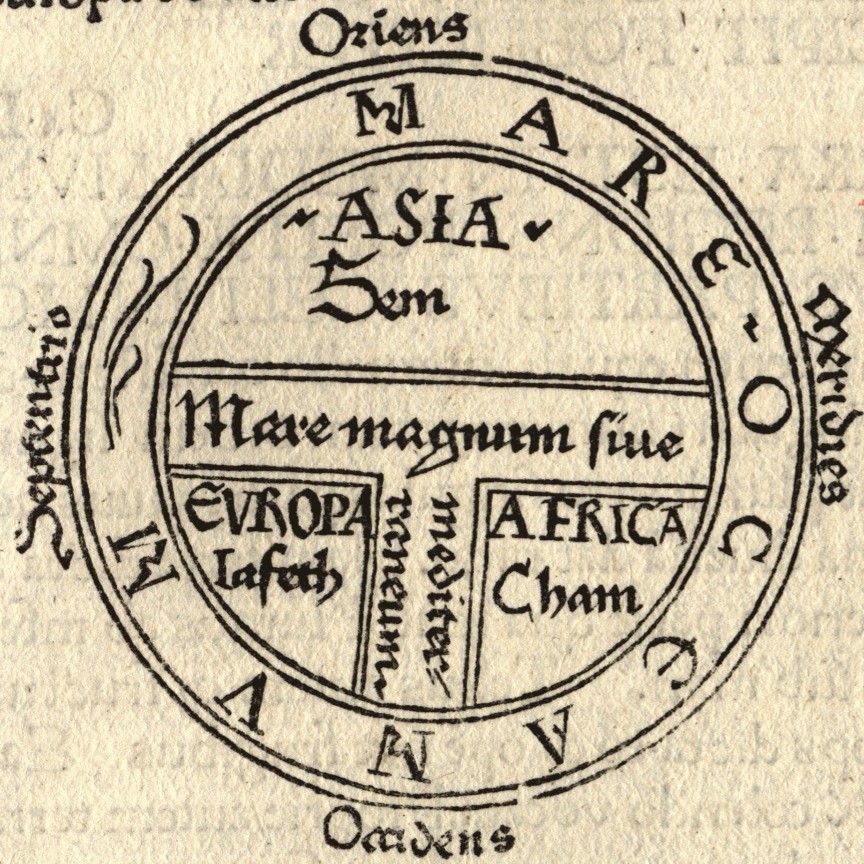
To continue my earlier post on maps, I thought I would go into some of the details of the mappa mundi. As many of you may know, the basic form for these maps is called the T-O map, since the main structure is a "T" inside an "O." The T and O are formed by water, so that the water bounds and shapes and encloses the land, even though the land takes up most of the space and is the focus of the map. The T is the Rivers -- the Mediterranean, the Nile, and the Tanais (i.e. the Don). The O is the ocean, a nameless circle that surrounds the land. The T also separates the continents, with Asia on top, Europe on the bottom left, and Africa on the bottom right. You can see in the above map that each continent is associated with one of Noah's sons: Asia with Sem (Shem), Europe with Iafeth (Japheth), and Africa with Cham (Ham). Jerusalem is at the middle of these maps, where the rivers and continents meet. This location means that Jerusalem was literally the center of the world, the most central and important location available. Move further from that center and things get . . . stranger. On the edges of the map are the so-called monstrous races. Human-like creatures with single feet, or with no heads, or with dog heads, populate the margins of the earth, far from Jerusalem and yet still part of the landed realms. An early (and still very informative) work about the monstrous races is John Bloch Friedman's The Monstrous Races in Medieval Art and Thought. There's also much interesting work being done on the placement of Great Britain on these maps, and more still to do. Both Asa Simon Mittman and Kathy Lavezzo have discussed the meaning for England, and English map-makers, that Great Britain is also on the edge of the world in these maps, and I suggest their work to those interested in the topic.

When I teach these maps, I try to get the students to discover the ways in which modern maps are constructed as well. We look at modern maps and discuss the things that aren't directly representative of the geography the maps depict. We talk about those things we've naturalized to the point of thinking they're just true. Since the aspect that surprises the students the most about medieval maps is that Asia is on top, I like to show them an Australian map which flips our normal sense of north as up. I ask why north is on top other than the fact that we've always seen it that way. Who decided? Maybe the fact that compasses point north (for now) had something to do with it, but it still has become the normal depiction to the point that most people think it's somehow natural. The "upside-down map" looks strange, the shapes of the continents unfamiliar, and this defamiliarization is useful for a number of reasons. One is that it helps us to see the geography anew, to attend to the details, since we rarely look as closely at the familiar (like the art assignment where students draw the human face upside-down). Another is that it allows us to think through the implications of the choices the mapmaker has made. What does it mean for north to be on top? What does it mean for Europe to be in the center? What does it mean to choose a projection which contracts and expands different parts of the world? I'm reminded of an episode of West Wing in which "The Organization of Cartographers for Social Equality" take their case to C.J. Cregg. At first, she laughs at the idea of maps having anything to do with social justice. But they show her how different projections alter the image of the earth, and her jaw drops as she realizes that they have a point.
Maybe I'll show that clip next time I teach this material.In any case, looking at different projections and different versions of world maps is a useful exercise, and we're all more ready to discuss the mappae mundi when we return to them. Yes, they're strange, but they're not stupid. And there's nothing inherently wrong with putting east on top. The verb orient comes from the fact that maps were originally oriented to the East (the Orient).

There is much to say about all of this, but I want to focus here on what is barely apparent on the maps: the ocean. Though the ocean forms the "O" and bounds the circle of the land, it nonetheless takes up very little space on the maps. We moderns, used to maps that depict the ocean as more than 70% of the earth's surface, may be surprised to see just how little ocean there is on these medieval world maps. I argue that this is not because medieval mapmakers misunderstood the ocean's vastness, but rather because their maps were ideological, encyclopedic, and aesthetic creations, and the ocean's place around the edges suited these purposes. It left the map symmetrical, but also left the land, and therefore those things that had happened on land, as the primary focus. The land in these maps is covered in classical and biblical and historical details associated with the various spaces on the earth. Humans are at the center of this narrative, and the land is humanity's realm.

There were other kinds of maps for navigating the ocean, and portolan charts helped seafarers from the 13th century on. The fact that mappae mundi and navigational maps were being produced simultaneously indicates that neither was meant to supersede or replace the other; they were simply for different purposes. The mappae mundi did precisely what they were meant to do -- they gave order to geographical and historical and spiritual information. And the land, and all of the things that had happened there in human history, was the focal point. The ocean is an unmarked space surrounding and outside of the land, more marginal indeed than the monsters that populate the edges of the world. The story is on the land, not the ocean, and thus the ocean depicts nothing; it is simply there to gird the earth. Unlike land, the ocean's topography cannot be marked or altered. It's both vast and unaffected (unaffectable) by humans. The contours of the ocean are ever-changing waves. How can you point to a historical location on the shifting contours of the water? How do you make your presence known to later people when you're floating on the sea? Humans may venture out onto the waters of the world in little wooden vessels, but these vessels will either be brought back to harbor or they will sink into the deep. (See my last post on Titanic for more about that.) No man-made contraptions can stay on the ocean's surface, none can leave a trace of human presence except in the depths of the ocean floor, subsumed by the ocean itself.

So the ocean is a blank space on these mappae mundi. It does not partake in the narrative domain of the land, nor does it participate in the historical or ideological aims of the land. It is a realm apart.

Friday, March 23, 2012

Making Our Way in the World: Musings on Medieval and Modern Maps and GPS

As my dissertation deals in many ways with medieval travel and medieval maps, I've been thinking a lot about my own travels and use of maps. Perhaps some of these musings will make their way into the introduction of my dissertation eventually. For now, I will begin to sketch out some of my thoughts here. Please let me know what you think.

**************************************************************

I've been on two different road trips across the United States. The first was when I moved from California to Rochester, and my old roommates travelled with me across the middle and north of the country. The second was when my mother moved to Rochester, and she and I drove her car down the west coast, across the south, and up the east coast. Both trips were beautiful and serious and silly, just as road trips should be. The topography and company was obviously different, but our mode of navigating was also quite different. My first trip was before I owned a GPS, and we made our way with an atlas, various state and regional maps, and (when Internet access allowed) google maps to help us out. My second trip was with a GPS in tow. We had a US atlas for good measure, but our days were spent following the green line across the screen of the GPS as we followed the highways through the windshield. Each trip was successful, both in the quality of the experience and in the fact that we arrived at our destination, but I can't help but think of the ways in which having a GPS on that second trip changed our relationship to the land around us. I have always felt that driving to a new home helps to make the move, and the distance, real. When my family moved from Alaska to California in my seventh year, we drove our truck from campground to campground, through the Yukon and down the 101. I had flown back and forth many times before that, but that drive lent a gravity to the move that those flights never did. But on that trip Mom and I let my father deal with navigation. He attempted to interest me in his various, haphazardly folded maps, but I was more interested in what was outside the windows than what was on those complicated pages. On my later grown-up trips, I had a more direct relationship with the planning and the map-looking. And thus I noticed the ways in which locating our own position in the country was different due to the different navigational methods.

With a map, one has a sense of the larger landscape. Even when a map contains a large dot and a "you are here," there's a greater framework for the individual location. That dot is in terms of the big picture. Context may vary according to the map in question, but context is nonetheless abundant. The surrounding area is available, as is an image of how different areas and landscapes and paths connect with each other. When I teach about medieval maps, I talk about how world maps relate to worldview. Maps depict the world metaphorically as much as literally, and medieval cartographers were no less making an accurate worldview as modern ones. In medieval maps, the worldview being so carefully depicted was different from ours, and the aims of the maps are therefore different, but the fact that they give a sense of worldview is the same. If anything, medieval maps are more clear about that fact than modern ones, with the modern notion of depicting the world as it "really is." What medieval world maps can teach us is how constructed maps really are, how much they can tell us not just about how to get from one place to another but also about the cultural mindsets that went into their creation. When my friends and I planned that first cross-country trip with maps and atlases, we gained some of that sense, whether consciously or not. We noticed the shapes of the states and therefore were confronted with the historical and geographical features that forged those boundaries between the individual puzzle pieces that make up this country. We saw how sometimes lakes or mountains manage to cross those borders as well as create them. We became aware of the things that are included in these maps, and the the things that aren't. At any given point in the trip, we could envision our relation to the rest of the trip as well as to all of the areas of the country outside of our path.

When I went on my second cross-country trip, we got some of this as well. I did examine an atlas from time to time, but for fun instead of for practical reasons, since we allowed the GPS to guide us completely. My father having recently passed away, and my mother's move occasioned in response to his death, the trip was cathartic for us. Since my dad loved maps so much, having some along felt right. But, without Dad in the car, the GPS navigated for us. It was a leisurely trip, and we made lots of stops to visit relatives and see sites of historical and/or geographical interest. And our GPS guided us faithfully every step of the way. I love that GPS, and it has never failed me. Mom and I even joked that it saved our good relationship, since getting lost can wreak havoc on family members in the close quarters of a compact vehicle. Yet I began to realize, as we followed its rather insistent directions without question, that watching the GPS screen was giving me a completely different view of the country than looking at a map would have done. A GPS only shows the direct area around the vehicle, and with only the most basic place names and other such features. A large enough river or lake might merit a blotch of blue on the screen, but most topographical features are excluded totally. The most notable feature of the GPS is the green line to indicate that you're going in the right direction (or the dreaded red line to warn you that you're going in the wrong one). In some ways, a map like this might make clear how far from the actual landscape maps actually are, its stylized representation of the country bearing so little resemblance to the view outside the car windows. But there's something else that distinguishes a GPS from other varieties of maps. A GPS gives a teleological view of geography. It's purpose is not to represent the country or region or state or town or neighborhood with any kind of totality but instead to get the driver from point A to point B. Larger context is shed and only the details that serve the purpose of the final destination are included. Anyone who has used a GPS has become painfully aware of this fact when attempting to make an unexpected detour. Dare to stop for a bathroom break or for lunch or to make a spontaneous visit to a roadside attraction, and the harsh tones of a phrase like "Turn back where possible" will repeat insistently until the passengers are forced to turn the sound off until back on the original path. As useful as the device is, it really is about the destination rather than the journey. The people of the Middle Ages had something for this purpose as well: the itinerary. Meant for pilgrims who needed to know how to get to a specific destination, itineraries were long, unfolding maps depicting the road and roadside details needed to find one's way from one place to another.


The aesthetic differences between the mappa mundi, or world map, and the itinerarium peregrinorum, or pilgrim's itinerary, are immediately apparent, as are the differences of purpose. While mappae mundi are aesthetic creations and visual encyclopedias that tell the viewer about his/her location in terms of a larger historical and spiritual narrative, itineraries give the traveler a means by which he/she can accomplish a journey. The former is of little practical use when trying to find one's way, though it may in fact have given people a sense of finding their way in a more cultural and spiritual sense. The second may give some practical guidance to the traveller (though, looking at itineraries, I am dubious of even how much they would have helped a medieval traveller). Finding one's way and locating one's self in the world are the province of each, but in a different way. Perhaps they give a different sense of narrative as well as geography. The way in which biblical and classical and contemporary history overlap on the world maps tells us something about the view of history such maps relate. They're densely textual, but the each piece of text only has meaning in terms of its spacial relationship to other bits of text or features of the map. The visual and the textual are inextricably bound. Itineraries are often colorful and beautiful, but they still give a sense of narrative as linear. They move the viewer from a beginning point at the bottom, before which there is nothing, to an endpoint at the top, after which there is nothing. A GPS is different, of course, in that the destination can be changed on a whim, and that the traveller can enter a new destination for each portion of the journey, but it still privileges destination. The device will do nothing until a destination is entered, and it only functions for any length of time when the car is on and it can be plugged in (helpfully reminding the user not to drive and work it at the same time). It is, in that way, for no other purpose than getting from place to place. Its ever changing screen allows for no contemplative functions, and that's OK. It serves its purpose well. Yet comparing different kinds of maps and navigational tools reminds me of the different ways in which we relate to our geographies, our histories, our lives. As I play with my apps from National Geographic World Atlas and Google Earth and watch as the screen zooms in from globe to individual location, I wonder about the multiplicity of ways in which we can view the world around us.