To continue
my earlier post on maps, I thought I would go into some of the details of the
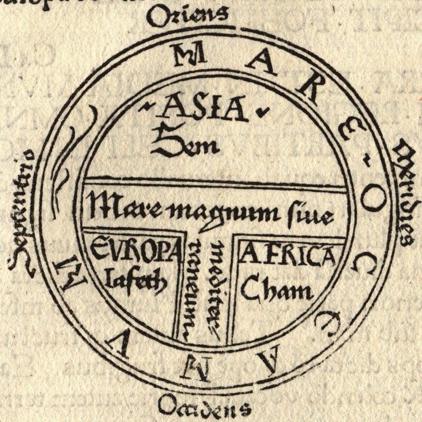
mappa mundi. As many of you may know, the basic form for these maps is called the T-O map, since the main structure is a "T" inside an "O." The T and O are formed by water, so that the water bounds and shapes and encloses the land, even though the land takes up most of the space and is the focus of the map. The T is the Rivers -- the Mediterranean, the Nile, and the Tanais (i.e. the Don). The O is the ocean, a nameless circle that surrounds the land. The T also separates the continents, with Asia on top, Europe on the bottom left, and Africa on the bottom right. You can see in the above map that each continent is associated with one of Noah's sons: Asia with Sem (Shem), Europe with Iafeth (Japheth), and Africa with Cham (Ham). Jerusalem is at the middle of these maps, where the rivers and continents meet. This location means that Jerusalem was literally the center of the world, the most central and important location available. Move further from that center and things get . . . stranger. On the edges of the map are the so-called monstrous races. Human-like creatures with single feet, or with no heads, or with dog heads, populate the margins of the earth, far from Jerusalem and yet still part of the landed realms. An early (and still very informative) work about the monstrous races is John Bloch Friedman's
The Monstrous Races in Medieval Art and Thought. There's also much interesting work being done on the placement of Great Britain on these maps, and more still to do. Both Asa Simon Mittman and Kathy Lavezzo have discussed the meaning for England, and English map-makers, that Great Britain is also on the edge of the world in these maps, and I suggest their work to those interested in the topic.

When I teach these maps, I try to get the students to discover the ways in which modern maps are constructed as well. We look at modern maps and discuss the things that aren't directly representative of the geography the maps depict. We talk about those things we've naturalized to the point of thinking they're just true. Since the aspect that surprises the students the most about medieval maps is that Asia is on top, I like to show them an Australian map which flips our normal sense of north as up. I ask why north is on top other than the fact that we've always seen it that way. Who decided? Maybe the fact that compasses point north (for now) had something to do with it, but it still has become the normal depiction to the point that most people think it's somehow natural. The "upside-down map" looks strange, the shapes of the continents unfamiliar, and this defamiliarization is useful for a number of reasons. One is that it helps us to see the geography anew, to attend to the details, since we rarely look as closely at the familiar (like the art assignment where students draw the human face upside-down). Another is that it allows us to think through the implications of the choices the mapmaker has made. What does it mean for north to be on top? What does it mean for Europe to be in the center? What does it mean to choose a projection which contracts and expands different parts of the world? I'm reminded of an episode of West Wing in which "The Organization of Cartographers for Social Equality" take their case to C.J. Cregg. At first, she laughs at the idea of maps having anything to do with social justice. But they show her how different projections alter the image of the earth, and her jaw drops as she realizes that they have a point.
Maybe I'll show that clip next time I teach this material.In any case, looking at different projections and different versions of world maps is a useful exercise, and we're all more ready to discuss the mappae mundi when we return to them. Yes, they're strange, but they're not stupid. And there's nothing inherently wrong with putting east on top. The verb orient comes from the fact that maps were originally oriented to the East (the Orient).
There is much to say about all of this, but I want to focus here on what is barely apparent on the maps: the ocean. Though the ocean forms the "O" and bounds the circle of the land, it nonetheless takes up very little space on the maps. We moderns, used to maps that depict the ocean as more than 70% of the earth's surface, may be surprised to see just how little ocean there is on these medieval world maps. I argue that this is not because medieval mapmakers misunderstood the ocean's vastness, but rather because their maps were ideological, encyclopedic, and aesthetic creations, and the ocean's place around the edges suited these purposes. It left the map symmetrical, but also left the land, and therefore those things that had happened on land, as the primary focus. The land in these maps is covered in classical and biblical and historical details associated with the various spaces on the earth. Humans are at the center of this narrative, and the land is humanity's realm.
There were other kinds of maps for navigating the ocean, and portolan charts helped seafarers from the 13th century on. The fact that
mappae mundi and navigational maps were being produced simultaneously indicates that neither was meant to supersede or replace the other; they were simply for different purposes. The
mappae mundi did precisely what they were meant to do -- they gave order to geographical and historical and spiritual information. And the land, and all of the things that had happened there in human history, was the focal point. The ocean is an unmarked space surrounding and outside of the land, more marginal indeed than the monsters that populate the edges of the world. The story is on the land, not the ocean, and thus the ocean depicts nothing; it is simply there to gird the earth. Unlike land, the ocean's topography cannot be marked or altered. It's both vast and unaffected (unaffectable) by humans. The contours of the ocean are ever-changing waves. How can you point to a historical location on the shifting contours of the water? How do you make your presence known to later people when you're floating on the sea? Humans may venture out onto the waters of the world in little wooden vessels, but these vessels will either be brought back to harbor or they will sink into the deep. (See
my last post on Titanic for more about that.) No man-made contraptions can stay on the ocean's surface, none can leave a trace of human presence except in the depths of the ocean floor, subsumed by the ocean itself.
So the ocean is a blank space on these mappae mundi. It does not partake in the narrative domain of the land, nor does it participate in the historical or ideological aims of the land. It is a realm apart.


A wonderful post written earlier this weeek by Anne at
ReplyDeleteMedieval Meets World discusses maps and Prester John, and it features a link to the clip from West Wing that I mention above.